Places in the South West Algarve
Home--
Interactive Map -- Lagos -- Tiffany's Riding Centre -- Holiday
Villas
More : - Praia da Luz and Burgau - Espiche and Almádena - Barăo de
Săo Joĺo
Val de Boi, Budens and Boca do Rio - Figueira, Salema and
Raposeira
Vila do Bispo, Sagres and Cape St. Vincent
For the Petition against construction in the Sudoeste Alentejo e Costa Vicentina Natural Park
Cavaleiros do Paz visit Boca do Rio
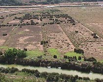
Vale de Boi
Along the EN 125, just past a turning north to the
Barőes, the tiny village of Vale de Boi lies south of the main road. Follow the narrow,
twisting lanes and find odd corners that are interesting to navigate, and you may discover
a local "tasca" or bar, and a restaurant. As there is no through road, you will
then have to find your way out again!
 |
 |
Vale de Boi from a track to the West |
A road in Vale de Boi |
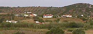
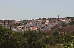
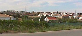
Budens
Another small old village on the edge of the main
Lagos to Sagres road. Records date it back to at least the beginning of the 14th century.
Now with much of the extended developement of Parque da Floresta to the north.
Tracks to the north, however, can take you on a magical
mystery tour into the National Forest and on to the west coast.
A road south leads to Boca
do Rio.
 |
 |
 |
Budens from the East |
Budens from the West |
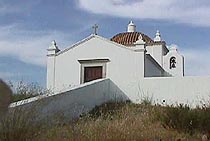
Chapel of Sto. António |
Boca do Rio
Boca do Rio (Mouth of the River) is reached
either by taking the road south from Budens, or taking the coast road west from
Burgau or the coast road east from the bus stop at Salema.
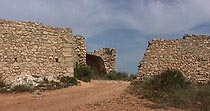
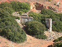
The Burgau road passes the track to the ruins of the 17th Century Almádena fort, before
turning inland to drop down and cross the river as a track and narrow unrailed bridge.
|
|
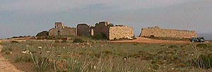
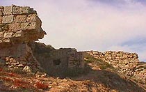
The ruins of the 17th Century Fortaleza S. Luís |
de Almádena. |
 |
The fort was constructed in 1632, during the reign
of Philip III. The order to build was given by the Governor of the Kingdom of the Algarve,
Dom Luís de Sousa. Much involved in this project was the Neapolitan Alexandre Massay, as
is mentioned in the Royal Charter of 1619. Alexandre never saw its completion, as he was
taken ill. The stone plaque, that used to be over the entrance, is now in Lagos Museum (St. Antonio Church). It reads "During the reign of King Philip III, Dom Luís de Sousa, Count of Prado, constructed at his own cost, constructed this fort dedicated to Saint Louis the Confessor, 1632." |
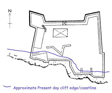
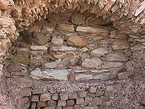
| Plan of the Fort |
For the Petition against construction in the Sudoeste Alentejo e Costa Vicentina Natural Park
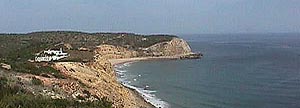
View from Almádena Fortaleza to Cabanas Velhas
A small fishing village stood here before the Great Earthquake of 1755. Some believe it was the original site of Almádena, because the present village does not have an old church, of the name of the Forteleza and the tidal wave report. Today the few ruins left by the resultant Tidal Wave, including those of the medieval chapel of Santa Elisabete, can be found across the Almádena river in the eastern valley that leads steeply up to the fort.
 |
 |
The old Salt Pans and Paddy Fields |
The Ruins |
THIS WILL DISAPPEAR _ HELP US FIGHT!
Petition against construction in the Sudoeste Alentejo e Costa Vicentina Natural Park
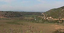
The valley looking upstream to Foia and Picota
The most striking building to be seen now is the dis-roofed storehouse (Armaçăo), which was used for storing the Tuna funnel nets, when Tuna fishing was a most profitable industry. This building is in a zone enclosed by a (now broken and rusty) chain-link fence, which designates the area in which Roman remains were found. The storehouse itself rests on Roman foundations. Looking along the foreshore, remains of Roman masonry can be seen. Examples of the mosaics are in Lagos Museum.
 |
 |
 |
The 18th century Tuna Net storehouse |
Roman Walls |
A small Roman Cistern? |
More recently the storehouse was used by Portuguese Underwater Archaeologists, to shelter their equipment, boats and finds. Just offshore between here and Salema, they first excavated the remains of the French Man-of-War 'L'Ocean', commanded by Admiral de La Clue, which sank as she came into shelter under the Almádena fort, escaping from Vice Admiral Boscowen and her defeat at the Battle of Lagos, 18th August, 1759. This wreck is now used as a training ground for Underwater Archaeology.
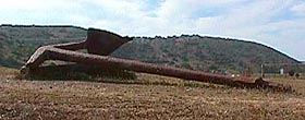 |
An Anchor and Iron Cannon from 'L'Ocean' |
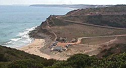
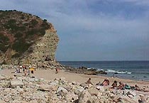
The small beach is often covered in pebbles and boulders, with the sandy part to the East. The old wooden beach bar is now demolished. From the end of the tarmac road, with its track to the beach on the left, the rough road leads up and over the hill to Salema. To the west of the tarmac road leading north to Budens is a small area of sandy soil which is a favoured place for Bee eater (Merops apiaster) nests.
 |
 |
View from the Fortaleza |
The Beach looking East |
Petition against construction in the Sudoeste Alentejo e Costa Vicentina Natural Park