Places in the South West Algarve
Home -- Interactive Map -- Lagos -- Tiffany's Riding Centre -- Holiday Villas
Other
Places
More : - Praia da Luz and Burgau - Espiche and Almádena - Barăo de
Săo Joĺo
Val de Boi, Budens and Boca do Rio - Figueira, Salema and Raposeira
Vila do Bispo, Sagres and Cape St. Vincent
Vila do Bispo
For numerous centuries this town was
known as the Aldeia do Bispo, or the Village of the Bishop. The Bishop in question was the
Bishop of Silves, within whose diocese it lies.
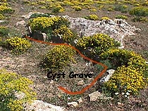
It is part of the 'Sacred Promontory' since ancient times, as is
shown by the stone Menhirs, and Bronze Age cyst
burials just to the south of the town.
 |
 |
__Menhir near the |
Bronze Age Cyst Burial __ |
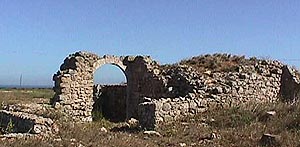
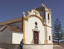
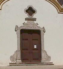
After the Great Earthquake (1st November 1755) only one house was
left standing. Amongst the ruins that were restored stands the parish church of Santa
Maria, with its pre-tremor Manuelin doorway (16th Century), and magnificent baroque
interior (18th Century).
 |
 |
 |
Igreja Santa Maria |
pre-16th Century doorway |
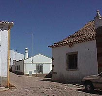
A road in Vila do Bispo |
No one has been able to work out where the Templo do Corvo, the Temple of the Ravens, was situated, other than being within the Sacred Promontory. This was the resting place of St. Vincent, martyred in 304 A.D., when his body was carried here by his followers. For many centuries it was a place of pilgrimage, said to have even rivalled Santiago do Compostela! As well as Christian pilgrims, Islamic pilgrims also visited the site, when the Moors controlled the area. A group of religious fanatics completely destroyed the chapel towards the end of the Arab occupation. In 1173, when the bones were rediscovered by two old monks, the remains were taken to Lisbon by sea, and St.Vincent adopted as patron saint of that city. The ravens were said to accompany the body of the saint on this journey, which is why the birds are incorporated in the heraldic arms of Lisbon.
On the old road at Vila do Bispo
Sagres
The name Sagres is derived from the Latin
Promentorum Sacrum, or the Sacred Promontory. Even before the Romans, this area was
considered to be sacred.
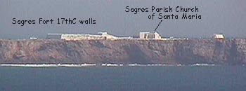
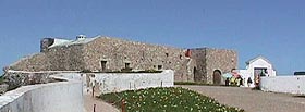
However, Sagres rose to fame when Prince Henry the Navigator chose
this somewhat bleak and windswept place to establish his Vila do Infante, or Town of the
Prince. Although there is little evidence to support the theory, it is thought that he
established a school for navigators on the southern peninsula. Here, within the remains of
the 17th Century fort, can be seen the enigmatic wind-rose, whose purpose is unclear, and
the church of Santa Maria, both of which are connected with Prince Henry.
The Vila do Infante was never a popular town, and many of the
original settlers in this remote location were serving out sentences of exile. When Prince
Henry died, in 1460, there was little incentive for them to remain, and the town declined
to such an extent that the population had to travel the 10 kilometres to Vila do Bispo to
hear Mass. Its name reverted to that of Sagres.
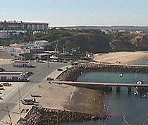
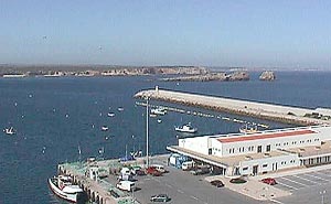
Now, with a Pousada, several hotels and numerous guest-houses, this
town is favoured by tourists who come for its associations with Prince Henry, its fishing
harbour, its small beaches, its dramatic cliffs and desolate scenery.
|
|
The ruins of Forteleza Balaeeira overlooking the harbour |
Sagres slipway and beach |
|
 |
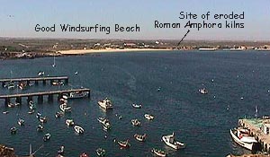
Sagres harbour looking to Martinhal |
The harbour arm, fish dock and Isles of Sagres |
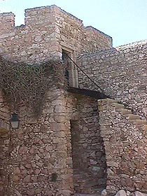
Beliche
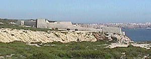
The site of one more of the chain of little
forts that guarded the coastline against pirates and corsairs in the 17th Century. Within
is a tiny chapel and a restaurant.
|
 |
Forteleza de Beliche looking towards Sagres |
North Tower |
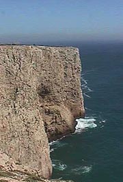
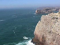
Cape St. Vincent
Believed to be the End of the World, until the
discovery and European colonisation of the Americas, this is where the cliffs of the most
South-westerly point of Europe jut into the Atlantic Ocean.
From the Phoenicians rounding the cape to head north for the tin
islands, to Sir Francis Drake, heading east to Cadiz, to modern-day yachtsmen, tankers and
freighters, this was and still is an important navigational reference point.
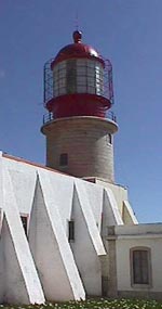 |
Perched above the edge of the rolling waves is a lighthouse, whose beam can be seen up to 32 miles away at sea. This landmark is set within the remaining buildings of the 17th Century Franciscan Convent. Originally a hermitage founded in the 13th Century A.D., the convent was established in the 15th Century. |
 |
|
The Lighthouse |
The Convent Buildings |
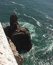
Several sea-battles have been fought within sight of these cliffs,
and the English Admiral, Jervis, received his title, Lord St. Vincent, after his great
naval victory here.
 |
|
|
Looking North |
Looking East. (Believe it or not, there is a fisherman somewhere on that cliff edge) |
Next stop - the Americas |
All photos taken 11th May 1999
Home -- Interactive Map -- Lagos -- Tiffany's Riding Centre -- Holiday Villas